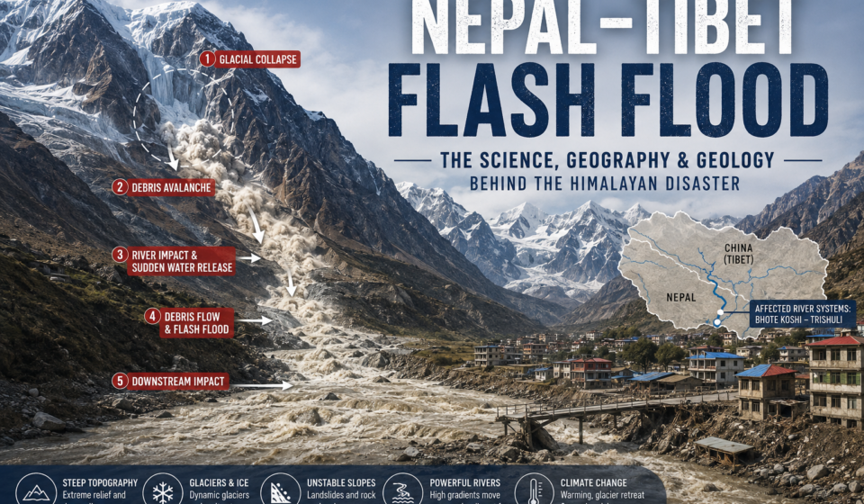

The Himalaya is one of the most geologically active and topographically extreme regions on Earth. Its enormous relief, rapidly flowing rivers, glaciers, unstable slopes and changing climate create a landscape where relatively localized failures can develop into destructive hazards far downstream.
The Nepal-Tibet flash flood of August 2026 is a powerful example of this interconnected mountain system.
The event was not simply a case of heavy rainfall causing a river to overflow. Preliminary scientific analysis indicates that a glacial collapse generated a debris avalanche that entered a mountain river system, rapidly transforming into a debris-rich flood that traveled roughly 100 kilometers downstream. The event affected areas on both sides of the Nepal-China border and followed the Bhote Koshi and Trishuli river corridors into central Nepal.
Understanding the disaster therefore requires looking beyond the flood itself.
The important questions are geological and geographical:
- Why are the Himalaya so susceptible to sudden slope failures?
- How can a glacier collapse produce a flood?
- Why can a disturbance high in the mountains affect valleys tens or hundreds of kilometers away?
- What role do glaciers, river gradients, sediment and climate play?
- Why are transboundary Himalayan floods particularly difficult to manage?
This article explores those processes.
Where did the Nepal-Tibet flash flood occur?
The affected region lies along the rugged Nepal-China border in the central Himalaya, where high glaciated mountains drain southward into steep river valleys.
The upper part of the affected drainage system lies near the Langtang region. From the high mountains, water and sediment move through tributary valleys before entering the Bhote Koshi and Trishuli river systems.
This geography is crucial.
A mountain river is not an isolated channel. It is the lowest point of an entire drainage basin. A landslide, glacier collapse or sudden release of water high in the watershed can therefore become a downstream river hazard.
The August 2026 event demonstrated this connectivity dramatically. USGS analysis indicates that the resulting debris flow and flood traveled approximately 100 km, affecting populated areas and infrastructure along the Trishuli and Bhote Koshi corridors, including areas across the border in China.
In other words, the flood was generated by a process in the high mountain headwaters, but its consequences were distributed throughout the downstream watershed.
The Himalaya: a landscape built by tectonic collision
To understand why these floods happen, it helps to begin with the geology of the Himalaya.
The Himalaya formed as the Indian Plate moved northward and collided with the Eurasian Plate. That collision continues today, producing enormous mountain relief and persistent tectonic deformation.
The result is a landscape characterized by:
- extremely steep slopes
- deep river valleys
- active faults and fractures
- highly elevated terrain
- glaciers and permanent snow
- frequent landslides and rockfalls
- powerful river erosion
The mountains are therefore constantly being reshaped.
Tectonic uplift raises rock. Weathering weakens exposed material. Glaciers carve valleys. Rivers remove sediment. Landslides move rock downhill.
The Himalayan landscape exists in a state of continual adjustment between these processes.
The geology around the 2026 event includes high-grade metamorphic rocks such as gneisses, quartzites and marbles, according to the USGS. These rocks form part of the complex geological framework of the high Himalaya.
Why steep Himalayan slopes are so unstable
Gravity is one of the simplest forces involved in the disaster.
A mountain slope becomes increasingly susceptible to failure as its inclination increases. The steeper the slope, the greater the component of gravity acting parallel to the slope.
But slope failure is not determined by steepness alone.
Rock strength, fractures, temperature, water pressure, ice, snow, geological structure and erosion all influence whether a slope remains stable.
In high Himalayan terrain, several processes can act simultaneously.
1. Glacial erosion
Moving glaciers are extremely effective agents of erosion. They remove and transport rock, deepen valleys and create steep mountain walls.
When glaciers retreat or change shape, slopes that were previously supported or buttressed by ice can become exposed.
2. Freeze-thaw weathering
At high elevations, water can enter cracks in rock, freeze and expand, and then thaw again.
Repeated freeze-thaw cycles gradually enlarge fractures.
Over long periods, this can transform solid-looking mountain faces into highly fractured rock masses.
3. River incision
Rivers continuously erode their channels.
When a river cuts downward into a steep valley, it can remove material from the base of a slope. This process, called toe erosion, can reduce slope stability and contribute to landslides.
4. Glacier retreat and changing ice support
Glaciers are not static blocks of ice. They are dynamic systems that respond to changes in temperature, snowfall and meltwater.
Changes in glacier geometry can alter the mechanical support of adjacent slopes and modify drainage pathways.
The result is a landscape where ice, rock and water interact continuously.
How can a glacier collapse cause a flood?
This is one of the most important scientific questions.
A glacier collapse does not necessarily mean that an enormous lake suddenly drains.
Instead, several processes can produce a flood.
A simplified chain looks like this:
Glacial instability → ice/rock collapse → debris avalanche → river blockage or direct river impact → sudden water release → debris flow → downstream flooding
The August 2026 event appears to have followed a process of this type.
USGS analysis indicates that a portion of a glacier collapsed and rapidly moved downslope. The collapsing material contained ice and water and entrained additional rock and sediment as it traveled. Once the material entered existing stream and river channels, it helped create a fast-moving, water-rich debris flow.
This distinction matters because the term flash flood describes the rapid hydrological response, not necessarily the original geological trigger.
The initiating event can be a landslide, glacier collapse, lake outburst, dam failure or extreme rainfall.
What is a glacial lake outburst flood?
One related process is a Glacial Lake Outburst Flood, commonly abbreviated as GLOF.
Glacial lakes form when meltwater accumulates near or on glaciers. Some are located behind natural dams made from glacial sediment, rock or ice.
If the dam fails, water can be released suddenly.
A GLOF can therefore transform a relatively contained body of water into a high-energy flood wave.
The Himalaya contain thousands of glacial lakes, and researchers have identified GLOFs as an important mountain hazard. Earlier studies have shown that growing glacier lakes and the frequency of lake outbursts are important controls on regional GLOF hazard.
However, not every Himalayan glacier-related flood is a GLOF.
That distinction is particularly important when discussing the August 2026 Nepal-Tibet event.
Early reports considered several possible mechanisms, including an ice-rock avalanche, temporary river blockage and glacial outburst processes. The scientific understanding is still developing, and the most defensible description is currently a glacial collapse/debris avalanche followed by catastrophic flooding, rather than assuming that a conventional moraine-dammed glacial lake simply burst.
The USGS currently describes the event as a debris avalanche and flash flood likely triggered by glacial collapse.
Why the flood became so destructive downstream
The destructive power of a Himalayan flood comes from more than water volume.
A sudden mountain flood can carry enormous quantities of sediment and debris.
These materials may include:
- boulders
- gravel
- sand
- fractured bedrock
- soil
- ice
- trees and vegetation
- human-made debris
This changes the physical behavior of the flow.
A normal river carries sediment within a relatively stable channel. A debris-rich flood can behave more like a moving mixture of water, mud, rock and ice.
As it moves downstream, it can also pick up additional material from the riverbanks and valley floor.
This creates a cascading process:
Initial collapse → water release → channel erosion → sediment entrainment → larger debris flow → downstream infrastructure damage
The valley itself becomes part of the disaster mechanism.
Why Himalayan rivers make the problem worse
Mountain rivers have steep gradients.
Elevation can decrease by thousands of meters over relatively short horizontal distances. This gives rivers enormous potential energy.
When a sudden flood enters such a channel, gravity accelerates the flow downslope.
Steep valleys also restrict the lateral movement of water.
Instead of spreading harmlessly across a wide floodplain, much of the flow can remain concentrated within a narrow gorge.
That concentration allows a flood wave to travel rapidly downstream.
The river corridor therefore acts as both a transport pathway and an amplifier of hazard.
From glacier to river: the importance of watershed geography
One of the most useful geographical lessons from the event is the concept of watershed connectivity.
A watershed links distant places through a common drainage system.
Consider the simplified sequence:
High Himalaya
↓
Glacier and mountain slope
↓
Small tributary
↓
Bhote Koshi/Lhende river system
↓
Trishuli River
↓
Narayani/Gandak system
↓
Ganges basin
A disturbance at the top of this system can therefore have consequences far beyond the location where it began.
This is why flood risk cannot be assessed solely at the location of a settlement.
The relevant question is:
What can happen anywhere upstream of this location?
For mountain communities, the answer may include landslides, glacier collapses, lake outbursts, rock avalanches and temporary landslide dams.
Temporary natural dams: another dangerous mechanism
A landslide or avalanche can sometimes block a river.
Initially, this may appear to reduce downstream flooding because water is temporarily trapped behind the debris.
But it creates a new hazard.
Water begins accumulating upstream of the blockage. As the lake grows, water can eventually overtop or erode the natural dam.
Once the blockage fails, the stored water and sediment can be released suddenly.
This is known as a landslide-dam outburst flood.
The process can therefore produce a two-stage hazard:
Slope failure → river blockage → temporary lake → dam failure → flood wave
This is one reason Himalayan floods can be difficult to predict from rainfall measurements alone.
The dangerous water may not yet be present in the downstream river.
It can be temporarily stored behind a geological obstruction upstream.
Why the event can occur without extreme rainfall
The phrase “flash flood” is sometimes interpreted as a synonym for intense rainfall.
That is too narrow.
Flash flooding describes a flood that develops rapidly. Rainfall is only one possible trigger.
The 2026 event is particularly instructive because the initiating mechanism appears to have been geological rather than a conventional rainfall-generated flood. USGS analysis points to a glacial collapse and subsequent debris flow as the principal process under investigation.
This distinction is important for flood forecasting.
A weather forecast can identify intense rainfall, but it cannot by itself predict every sudden glacier collapse or landslide.
Mountain hazard monitoring therefore requires multiple types of information:
- rainfall observations
- river levels
- satellite imagery
- glacier conditions
- ground deformation
- seismic signals
- lake expansion
- slope stability
- historical landslide activity
The modern science of Himalayan hazards increasingly depends on combining these datasets.
The role of climate change
Climate change is an important part of the larger Himalayan hazard picture, but it should be discussed carefully.
It would be misleading to say that climate change directly “caused” a particular glacier collapse without event-specific evidence.
A better way to understand the relationship is through hazard conditioning.
Warming temperatures can contribute to glacier mass loss and retreat. Changing glacier geometry can create or enlarge meltwater lakes, modify drainage systems and expose previously ice-covered terrain.
Research on the Himalaya-Karakoram region indicates that glacier retreat and changing cryospheric conditions are associated with expanding glacial lakes and increasing concern over GLOF hazards.
At the same time, individual failures remain controlled by local conditions.
A useful framework is:
Climate change changes the background conditions.
Geology determines what can fail.
Topography determines where material moves.
Hydrology determines how water is transported.
Human geography determines who and what is exposed.
That interaction is much more scientifically useful than attributing every Himalayan flood to climate change alone.
Why transboundary floods are especially challenging
The Nepal-Tibet border is also a hydrological boundary.
But rivers do not stop at national borders.
A glacier or landslide may be located in one country while the most severe consequences occur downstream in another.
This creates a fundamental geographical problem:
The source of the hazard and the location of exposure may be separated by an international boundary.
Researchers have identified transboundary glacial hazards as a significant issue in the Hindu Kush-Karakoram-Himalayan region. Some potentially hazardous lakes and drainage systems can affect downstream communities across national borders.
Effective risk reduction therefore requires cooperation in:
- satellite monitoring
- hydrological data
- glacier observation
- seismic monitoring
- flood forecasting
- emergency communication
- infrastructure planning
The watershed is continuous even when political geography is not.
Why infrastructure is particularly vulnerable
Mountain infrastructure is often concentrated along rivers because valleys provide the only practical routes through difficult terrain.
Roads, bridges, hydropower facilities, settlements and border trade routes therefore tend to occupy exactly the corridors through which a major flood would travel.
This produces a geographical paradox.
The river valley is the safest and most practical route for transportation and development under normal conditions.
But during a major flood, it can become the principal hazard corridor.
Hydropower illustrates this especially well.
Mountain rivers provide excellent gradients for hydropower generation, but facilities placed close to channels are exposed to floods carrying enormous quantities of sediment and debris.
The same topography that creates economic opportunity can therefore create geological risk.
Why satellite imagery is so important
Remote sensing has become one of the most valuable tools for understanding Himalayan disasters.
Satellites can compare the landscape before and after an event.
Scientists can identify:
- glacier changes
- new landslides
- collapsed slopes
- temporary lakes
- flood extent
- sediment deposits
- channel changes
- damaged infrastructure
This is particularly important in high-altitude regions where field access can be difficult or dangerous.
In the 2026 event, USGS scientists used satellite imagery to map the flood and debris-flow extent and identify disturbed terrain.
Remote sensing does not replace field geology, but it allows scientists to rapidly reconstruct an event across terrain that may be inaccessible immediately after a disaster.
The 2025 Rasuwa flood provides an important comparison
The broader region experienced another major glacier-related flood in July 2025.
That event was linked to the rapid drainage of a large supraglacial lake on the Purepu Glacier in Tibet. Nepal’s National Disaster Risk Reduction and Management Authority reported that the lake had expanded substantially before rapidly shrinking during the flood event.
Later scientific research documented exceptional supraglacial lake outburst floods along the China-Nepal border in 2025 and found that unusually large supraglacial lakes, complex englacial drainage and hydrofracturing were involved.
The comparison is useful because it demonstrates that “Nepal-Tibet flash flood” is not one single geological process.
The region can experience several related hazards:
- glacial collapse
- supraglacial lake outburst
- moraine-dammed lake failure
- landslide-dam outburst
- debris flow
- rainfall-triggered landslide
- conventional river flooding
The common factor is the extreme connectivity between glaciers, slopes and rivers.
A useful way to think about Himalayan flash floods
The best conceptual model is not simply:
Rain → Flood
In the high Himalaya, a more complete model is:
Climate + geology + topography + glaciers + water + sediment + gravity
These components interact.
For example:
Glacier changes can alter slope stability.
Slope failure can introduce ice and rock into a river.
River blockage can temporarily store water.
Dam failure can release that water suddenly.
Steep topography accelerates the flow.
Sediment entrainment increases the destructive capacity.
Narrow valleys concentrate the flood.
Human infrastructure increases exposure.
The disaster is therefore best understood as a coupled geomorphological and hydrological process.
What the Nepal-Tibet flash flood teaches us about geography
The most important lesson is that natural hazards rarely respect the boundaries between scientific disciplines.
A glacier problem can become a river problem.
A landslide can become a flood.
A flood can become a sediment-transport problem.
A geological event can become an infrastructure disaster.
And an event in one country can become a humanitarian and environmental problem downstream in another.
This is the essence of physical geography: landscapes are systems, not collections of isolated features.
The August 2026 Nepal-Tibet flash flood is therefore more than an isolated disaster. It is an example of how the Himalayan landscape transfers energy, water and sediment from high elevations toward densely occupied river valleys.
What scientists will be looking at next
As more satellite imagery, field observations and geological data become available, researchers will be able to refine the reconstruction of the event.
Important questions include:
- Exactly where did the initial glacial collapse occur?
- How much ice and rock failed?
- How much water was released directly by the collapse?
- Did a temporary river blockage form?
- How much additional sediment was eroded downstream?
- How did the flood wave change as it entered larger rivers?
- Which geological structures controlled the initial failure?
- What role did recent glacier and climate changes play in preparing the landscape?
- Which upstream locations should be monitored for similar hazards?
Answering these questions is more valuable than simply determining the size of the flood.
It helps scientists understand whether similar events could happen elsewhere.
Conclusion
The Nepal-Tibet flash flood shows why the Himalaya must be understood as an interconnected Earth system.
The event began in an environment shaped by tectonic uplift, glaciation, erosion and extreme topographic relief. A likely glacial collapse transformed into a debris avalanche and flood, which then used the existing river network to move rapidly downstream.
The result was a hazard that crossed physical and political boundaries.
For geographers, the most important lesson is simple:
A flood does not begin where the water becomes visible.
Its origins may lie kilometers upstream, on a glacier, beneath an unstable slope or behind a temporary natural dam.
Understanding that upstream-downstream connection is essential for understanding Himalayan hazards.
And as glaciers, slopes and hydrological systems continue to change, the science of mountain hazards will increasingly depend on understanding these connections before the next flood occurs.
